
Gran Canaria can offer much more than bar & beach fun. If you let it. If you are looking to discover an island with majestic mountains, luxuriant vegetation and natural wonders, you’ve come to the right place! The hikes we suggest are between 6 and 11 kilometres long. Long enough for you to get a good dose of that nature-induced drug of dopamine, yet still manageable without feeling you got beat by a baseball bat the day after. And these 5 hikes will reveal some of the many faces of this marvelous miniature continent.
Last year we spent 2 months roaming the countryside of Gran Canaria with Las Palmas as base. We found that the public transport will go a long way, as the capital of Gran Canaria is very well connected to some amazing nature areas. Only one of our hikes required a car. The rest of the hikes are no more than max. 70 minutes away by bus.
As the weather is pleasant and stable all year round, the Canary Islands are the perfect place for an active holiday. Especially in the wintertime, when we want to escape to cold and darkness of our northern addresses, and fuel up on light, landscape and laughter. And hopefully shed a few pounds while we’re at it. Let’s get hiking!
Caldera de Bandama
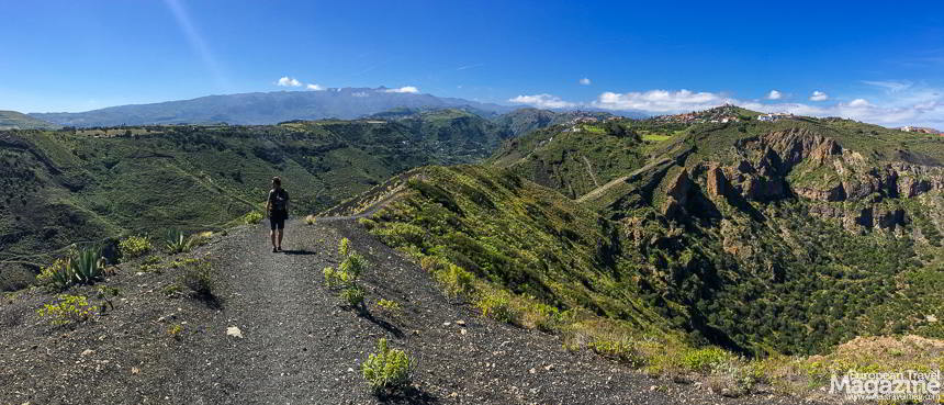 Ever walked round the crater of an extinct volcano? Me neither, until I visited Gran Canaria, and after only 1/2 hour bus ride from the bustling city of Las Palmas, could stare into the empty cauldron of Bandama volcano. Thrilling!
The hike around the edge of the volcano is only 3,7 km, but will award you with amazing views of Las Palmas to the north, the sea to the east and highlands of the west. When you’re done with the hike around the edge, descend into the crater and down to the bottom, to absorb yourself in the nature, as the impressive vertical walls isolate you from the world outside. A hike round the bottom of the volcano and back to your starting point will only add up to 6,5 km, but with plenty of vertical metres.
A couple of restaurants near the bus stop will provide you with sustenance, while you’re waiting for the bus to take you back to las Palmas.
-

- An information panel tells the fascinating, geological tale of the volcano

-

- The hike is well signed

-

- Start by walking the edge of the crater

-

- The hike offers spectacular views to the surrounding countryside

-

- ..as well a view down the crater of the volcano

-

- You can descend into the crater after circling the edge

-

- You are isolated from the world outside at he bottom of the crater

-

- DATA: 6,5 KM – 411 M ELEVATION UP – 411 M. ELEVATION DOWN – MODERATE DIFFICULTY
DATA: 6,5 KM – 411 M ELEVATION UP – 411 M. ELEVATION DOWN – MODERATE DIFFICULTY
- Link to the hiking trail in Wikiloc
- Google Maps Bus route from San Telmo Bus Station to Caldera de Bandama Bus Stop
- Caldera de Bandama on Canarian Islands website
Teror and Cruz de Hoya Alta
 Teror is worth a visit in itself. A quiet, crisp escape from Las Palmas (at least it’s quiet off-season!), Bus 216 will take you there in only 45 minutes every hour on the hour. The terraced hillsides brought to mind the rice terraces of the east, as we roamed the countryside. We had at least 3 good walks in this area, and chose this as our favourite.
The beginning may be a bit dull, but as you get deeper up into the hills and immerse yourself in the nature, the hike becomes a study in the special landscape of Teror. Standing at the base of the 120-year-old cross of Hoya Alta and looking out at the countryside is breathtaking. And it doesn’t hurt that Teror has a nice selection of cafés, restaurants and watering holes to replenish your depots when you’re finished.
Check out the weather forecast before you go, and pack an extra layer: it’s cooler in the mountains!
-

- Teror is worth a visit in itself. A quiet, crisp escape from Las Palmas

-

- The terraced hillsides brought to mind the rice terraces of the east, as we roamed the countryside

-

- As you get deeper up into the hills and immerse yourself in the nature..

-

- ..the hike becomes a study in the special landscape of Teror.

-

- The nature is full of colourful flowers like this

-

- We had at least 3 good walks in this area, and chose this as our favourite.

-

- Standing at the base of the 120-year-old cross of Hoya Alta and looking out at the countryside is breathtaking

-

- DATA: 7,5 KM – 481 M ELEVATION UP – 481 M. ELEVATION DOWN – MODERATE DIFFICULTY
DATA: 7,5 KM – 481 M ELEVATION UP – 481 M. ELEVATION DOWN – MODERATE DIFFICULTY
- Link to the hiking trail in Wikiloc
- Google Maps Bus route from San Telmo Bus Station to Teror
- Teror on Gran Canaria’s official Tourism website
Barranco de Las Vacas
This trail starts at the bus stop in Temisas and follows the Camino Real to let you discover the wondrous Barranco de Las Vacas, also called Barranco de Barafonso, before finishing in Aguimes, where you can celebrate with a well-deserved brewski. While the bus ride to Temisas will take 1 hour and involve one change of bus, from Aguimes you will have direct connection to Las Palmas in 50 minutes.
With this hike, you’ve left the jungle-green density of northern Gran Canaria in favour of a more desolate landscape, defined by soft hills carved out by ravines. And on your trip you will descend into a ravine which like we have only seen in pictures of Antelope Canyon in Arizona. It’s amazing!
The hike itself is pretty easy, as you’ve taken the bus up in the hills and can now capitalize on the gently descent of the Camino Real trail towards the sea to Aguimes, where a bus can take you back to Las Palmas.
-

- With this hike, you’ve left the jungle-green density of northern Gran Canaria in favour of a more desolate landscape

-

- On your trip you will descend into this ravine which like we have only seen in pictures of Antelope Canyon in Arizona

-

- Barranco de Las Vacas is also called Barranco de Barafonso

-

- I will let the pictures speak for themselves. The place is magical!

-

- Golden colours and soft rock

-

- It’s a unique landscape in Gran Canaria

-

- When you reach Aguimes you can celebrate with a well-deserved brewski

-

- DATA: 10,2 KM – 203 M ELEVATION UP – 602 M. ELEVATION DOWN – MODERATE DIFFICULTY
DATA: 10,2 KM – 203 M ELEVATION UP – 602 M. ELEVATION DOWN – MODERATE DIFFICULTY
- Link to the hiking trail in Wikiloc
- Google Maps Bus route from San Telmo Bus Station to Temisas Bus Stop
- Barranco de Las Vacas on Gran Canaria Info website
Roque Nublo
 While there are plenty other trails to hike in the vicinity of Las Palmas, some are just so exceptional that they are worth the trouble to get there. The hike to Roque Nublo is that kind of hike. You’ll have to rent a car in order get there, unless you want to spend 2-3 hours in a bus. However, renting a car is not that expensive. We rented a car for one day for under 40€.
More tips for a Great Gran Canaria break:
The hike starts at the car park and is quite straightforward. Just follow the trail of tourists and keep walking towards the easy-to-spot volcanic rock of Roque Nublo. On your way you will encounter “The Friar”; a rock formed like a praying priest, as well as some magnificent views to a majestic landscape.
On the way back from Roque Nublo turn right at the signage and follow S-70 towards El Aserrador for while, but turning right in the woods instead of left, in order to circulate the hillside and trek the area east of Roque Nublo before you return to the parking lot.
-

- While there are plenty other trails to hike in the vicinity of Las Palmas, some are just so exceptional that they are worth the trouble to get there

-

- The hike to Roque Nublo is that kind of hike.

-

- The hike starts at the car park and is quite straightforward. Just follow the trail of tourists and keep walking towards the easy-to-spot volcanic rock of Roque Nublo

-

- On your way you will encounter “The Friar”; a rock formed like a praying priest

-

- ..as well as some magnificent views to a majestic landscape.

-

- On the way back from Roque Nublo turn right at the signage and follow S-70 towards El Aserrador for while

-

- Circulate the hillside and trek the area east of Roque Nublo before returning to the parking lot

-

- DATA: 5,82 KM – 401 M ELEVATION UP – 401 M. ELEVATION DOWN – MODERATE DIFFICULTY
DATA: 5,82 KM – 401 M ELEVATION UP – 401 M. ELEVATION DOWN – MODERATE DIFFICULTY
- Link to the hiking trail in Wikiloc
- Google Maps Car route from Las Palmas to car park at Roque Nublo
- Roque Nublo on Canarian Islands website
Jardín Canario and Guiniguada Ravine
 You’ve probably noticed by now how lush and exotic Gran Canaria is, and this botanic garden showcases and celebrates its diverse nature. The Jardín Canario Viera y Clavijo is only a 15-minute, 1.4€ bus ride from the city centre and well worth the trip. Not only because it’s totally free but really just because it’s ravishingly beautiful.
Walk among Dragon Blood trees and huge cactuses and traverse this slopes of the ravine down do the bottom of the ravine, or barranco, as it’s called. It’s like walking down a vertical jungle, and every turn affords new views. At the bottom, the garden continues to showcase different kinds of the more than 500 endemic, canarian plants that beautify these fine isles.
When you’re done, scramble your 9 kilometres back to Las Palmas through the Barranco de Guiniguada. It’s a pretty easy hike, gently sloping to your advantage and will end in the historic Triana neighbourhood, where shaded cafés will award you with ice cold drinks.
-

- The Botanic Garden Jardín Canario Viera y Clavijo celebrates the diverse nature of the Canary Islands

-

- Walk among Dragon Blood trees and huge cactuses..

-

- ..and traverse this slopes of the ravine down do the bottom of the ravine, or barranco, as it’s called.

-

- It’s like walking down a vertical jungle, and every turn affords new views.

-

- At the bottom, the garden continues to showcase different kinds of the more than 500 endemic, canarian plants–

-

- ..that beautify these fine isles.

-

- When you’re done, scramble your 9 kilometres back to Las Palmas through the Barranco de Guiniguada

-

- DATA: APPROX 10 KM – 32 M ELEVATION UP – 325 M. ELEVATION DOWN – EASY DIFFICULTY
DATA: APPROX 10 KM – 32 M ELEVATION UP – 325 M. ELEVATION DOWN – EASY DIFFICULTY
- Link to the hiking trail in Wikiloc
- Google Maps Bus route from San Telmo Bus Station to Jardin Botanico
- Jardín Botanico website with map of the botanic garden
More info
Learn more


