
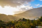
The Scottish highlands offers some of the best adventures for lovers of the outdoors. From the contrasted Cairngorms National Park in the east to the bleak beauty of Isle of Skye in the west, the National Parks of Scotland is pure nature. And just now, in the glorious autumn, when the sun pierces the golden leaves and sets the withered ferns on fire, the landscape is at its most beautiful.
We’ve compiled a list of our favourite hikes in this untamed part of Scotland and hope they will inspire you to take a trip into the wild and leave with memories of a lifetime.
Cairngorms National Park
This National Park is the largest in Britain and offers great many hiking options, around the lush Deeside in the east and the more wild parts around the Cairn Gorm Mountains in the west. Indeed, even the fauna here is incredibly diverse, with mixed forestry at the base of the mountains and a sub-polar plateau at the top with alpine plants.
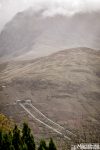
Our favourite hike in this area was in Glenmore forest park near Aviemore in the western part of the park, just 50 kilometres south of Inverness. Our hike led us from the tranquil forest lake of Loch Morlich into the woods and up to An Lochan Uaine, which means “small green loch”, through Ryvoan Pass, up to Meall a’ Bhuachaille, a so-called Corbett (peaks that are between 762 and 914 metres high) at 810 metres. An awarding hike at 8,5 kilometres and 543 metres of ascent.
-

- Cairngorms is also home to The Balmoral Castle, where Queen Elizabeth resides when in Scotland (this is not it, though!)
-

- Autumn is the most beautiful time to visit this national park
-

- Strathspey Railway has an old steam locomotive that goes through the national park
-

- The hike in Glenmore forest park offers both charming woodlands and epic scenery
-

- The contrast is overwhelming
-
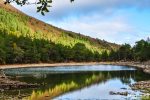
- Our hike led us into the woods and up to An Lochan Uaine, which means “small green loch”
-

- ..through Ryvoan Pass.. (sounds like something from Lord of the Rings!)
-
- The road up to Meall a’ Bhuachaille offers stunning vistas
Isle of Skye
The largest of the Inner Hebrides may now be connected to the mainland via bridge, but it maintains its isolated atmosphere. It has become a huge tourist magnet and you’re lucky if you can find parking spots at the scenic hiking routes we’ve recommended. If you can look past the convoys of rental cars and Asians climbing in white sneakers the desolate beauty of Skye has inspires poets and artists, ever since the Vikings showed up, saw how it looked like home – and stayed.
Old Man of Storr
The name of our first hiking destination on the Island is said to be derived from Norse, where Storr means “Big”. And “Big Old Man” certainly is an impressive sight to behold. But more impressive is the view from the top, where misty mountains and a glittering sea make a contrasted backdrop to the black monoliths of Storr.
The hike is pretty straightforward: just follow to tourist in front of you. Ascent to the Storr, go around and enjoy the magnificent vistas before ascending, making it a 4.5-kilometre climb with 288 metres ascent.
-

- The name of our first hiking destination on the Island is said to be derived from Norse, where “Storr” means “Big”
-

- The hike is pretty straightforward: just follow to tourist in front of you
-

- But more impressive is the view from the top
-

- This landscape is out of this world
-
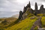
- Misty mountains and a glittering sea make a contrasted backdrop to the black monoliths of Storr.
-

- And “Big Old Man” certainly is an impressive sight to behold!
Fairy Glen
The cutest hike of them all. You almost can’t call it a hike, but rather a leisurely stroll through a fairy landscape. Although Skye has a long history involving fairies, there are no legends of the little people tied to this otherworldly landscape. But you only need a little bit of imagination to turn the hill with the flat top into a ruin fairy castle. The fact that it’s actually called Castle Ewan emphasises how it has inspired folks throughout the ages.
The road to the glen is quite narrow and to avoid parking pandemonium, we parked in nearby Uig, making it a 5,5 kilometre hike instead of the 2 kilometre route we found on Walkinghighlands.
-
- The cutest hike of them all
-

- You almost can’t call it a hike, but rather a leisurely stroll through a fairy landscape
-

- But you only need a little bit of imagination to turn the hill with the flat top into a ruin fairy castle
-

- The fact that it’s actually called Castle Ewan emphasises how it has inspired folks throughout the ages
-

- Although Skye has a long history involving fairies, there are no legends of the little people tied to this otherworldly landscape
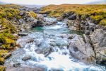
Fairy Pools
Another favourite among the tourists. When – IF the weather is fair, this hike offers charming small waterfalls and green-blue ponds, framed by a spectacular scenery of the Black Cuillins. When it’s NOT fair and the Scottish mist prevents any glorious vistas, it’s rather dull. If I were you, I would then rather stop by at Talisker and wait for the weather to clear up..
-
- This hike deserves fair weather in order for the black Cuillin mountains to make this shot work
-
- IF the weather is fair, this hike offers charming small waterfalls and green-blue ponds
-

- The waters look inviting but are freezing!!
-
- When not misty, the surrounding is framed by a spectacular scenery of the Black Cuillins
-

- When the weather is NOT fair and the Scottish mist prevents any glorious vistas, it’s a rather dull hike..
-

- Want to swim with the fairies?
Glenfinnan
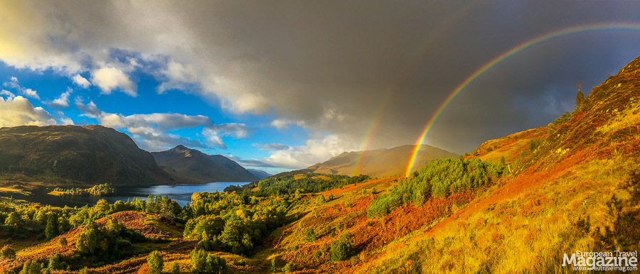
On the way south from Inverness to Fort William, you turn left to go to Glen Nevis and right to go to Glenfinnan. The Glenfinnan Viaduct Trail offers the best of history, nature and pop-culture in less than 4 kilometres. It is:
A: The viaduct, made famous by the Hogwarts steam train ride in the Harry Potter movies
B: A monument, marking the spot where the Jacobite Pretender, Bonnie Prince Charlie, came ashore on Scottish soil to lead an uprising against the British monarch.
C: A stunning view to the 4th longest loch in Scotland, Loch Shiel and its picturesque surroundings.
The trail is very easy and will probably be a favourite among the kids. For those interested in history, a small but enlightening mini-museum in the Glenfinnan Visitor Centre about the Bonnie Prince Charles, adds some historic depth to the hike. We hiked the trail in the morning, just when the sun came over the surrounding mountains, and were awarded with a double rainbow and stunning views.
-

- Glenfinnan monument, marking the spot where the Jacobite Pretender, Bonnie Prince Charlie, came ashore on Scottish soil to lead an uprising against the British monarch
-
- We hiked the trail in the morning, just when the sun came over the surrounding mountains
-
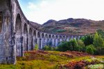
- The viaduct is made famous by the Hogwarts steam train ride in the Harry Potter movies
-

- The hike offers stunning views to the 4th longest loch in Scotland, Loch Shiel and its picturesque surroundings
-

- [insert Hogwarts Train here]
-

- A hike in the morning might be awarded with a double rainbow and stunning views
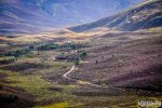
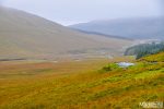
Glen Nevis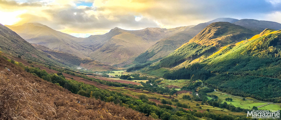
The valley at Ben Nevis’ feet lies just east of Fort William, the self-proclaimed outdoor capital of the UK. A campsite, Youth Hostel and self-catering cottages provide the hot shower you crave after hiking the whole day. The glen is inviting and several hiking routes makes this a preferable area for trekking, if the weather on Ben Nevis proves too harsh.
From the Visitor Centre car park, go up to the forestry track that forms part of the West Highland Way. Walking along the side of the mountain offers beautiful views over the valley and the unforgiving massif of Creagan nan Gabhar and Carn Dearg, the two preludes to Ben Nevis. The trail descends into the road and the Polldubh Falls, where the River Nevis plunges over a 10 metre drop. Following the river back to the car park makes this a 13-kilometre hike with only 288 vertical metres to conquer.
-

- The valley at Ben Nevis’ feet lies just east of Fort William, the self-proclaimed capital of the UK
-

- The glen is inviting and several hiking routes makes this a preferable area for trekking, if the weather on Ben Nevis proves too harsh
-
- The forest clad in autumn colours
-

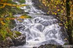
- The upside of Scottish rain is a lot of waterfalls!
-

- The unforgiving massif of Creagan nan Gabhar, a prelude to Ben Nevis
-

- Walking along the side of the mountain offers beautiful views over the valley
Ben Nevis
“The Ben”, as the locals lovingly calls it, is highest mountain in Britain and a feat to climb with its 1.346 metres, even if you take the “highway”, also called Old Bridle Path, to the top. This rocky footpath will, however, feel more like a highway if you venture to the top on one of those rare sunny days when everybody else seems to have got the same idea. But don’t let the swarm of fellow hikers put you off, there are plenty of kilometres of path to share, as you will have to walk 8 kilometres to get to the top. And even if the climb is pretty straightforward, some of your fellow hikers won’t make it.
I’m not talking about those unlucky few that die on Ben Nevis every year, only those that find it too exhausting and choose to turn back when the weather’s getting rough near at the top.
We started our climb on a beautiful, sunny day and enjoyed the magnificent vistas of Glen Nevis at our feet as we climbed higher. Eventually we reached the clouds and it was “Goodbye vistas”. Another hour of painfully repetitive climbing in weather, that was getting more and more cold, got us to the top. Among whirling snowflakes and bittercold winds, we quickly snapped our selfies with a smartphone that detested the cold to an extent that it dropped to half the battery life. A woollen sweater, added to shield against the cold on the descent, made the climb halfway down a warm, fuzzy experience, improving to the fun that we could encourage approaching climbers with a merry “Almost there, buddy” to cheer them on.
Descending from the clouds allowed us to enjoy the remaining sunshine and glorious weather in the valley before rewarding ourselves with a hot shower and dry clothes.
-
- You can’t get to the top in one of the Gondolas, but if your feet won’t drag you to the top, you can always enjoy the view..
-

- “The Ben”, as the locals lovingly calls it, is highest mountain in Britain and a feat to climb with its 1.346 metres
-

- You can’t see Ben Nevis from the valley – but it’s up there!
-

- We started our climb on a beautiful, sunny day and enjoyed the magnificent vistas of Glen Nevis at our feet as we climbed higher
-

- Eventually we reached the clouds and it was “Goodbye vistas”
-

- It’s true what they say: “It’s cold on the top”!
-

- Descending from the clouds allowed us to enjoy the remaining sunshine and glorious weather in the valley
Glen Coe
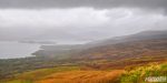
Bleak beauty in an epic landscape. That is Glen Coe, the area south of Glen Nevis, regarded as the home of Scottish mountaineering. The main A82 road cutting through the valley will provide you with spectacular views, no wonder it’s one of the Top Scenic Routes in Scotland. To take in the whole, majestic panorama, however, you have to park your car and get rambling!
We chose a route that would allow us to “bag” two Munros (peaks that are over 914 metres high) on the Buachaille Etive Beag mountain and walk along a magnificent ridge, making the most of the views of the peaks of Glen Coe.
Our legs, still jelly after Ben Nevis, commanded multiple stops on the ascent. We were wise to pause on the way up, because at reaching the first cairn on the ridge, the chilling winds from the other side of the mountain didn’t invite to sit down and have picnic. If you’re sure you have enough mojo in your legs, start climbing the Munro to your left, Stob Coire Raineach at 923 metres. It’s a steep but short climb, that will allow stunning views over Glen Coe. In fair weather, you can see all the way to Ben Nevis, making this a magnificent hike.
When you bagged this, retrace your steps back to the cairn and go for the cone-shaped Stob Dubh at 954 metres. The walk along the narrow ridge is exhilarating and the views of Loch Etive and its Glen from the top is epic. We met an elderly gentleman planning on continuing further and “bag” the two Munros on Buachaille Etive Mor mountain to the east as well, climbing no less than four Munros in one day. What a feat!
-

- Bleak beauty in an epic landscape
-

- To take in the whole, majestic panorama of the area, you have to park your car and get rambling!
-

- The walk along the narrow ridge is exhilarating and the views of Loch Etive and its Glen from the top is epic
-

- There’s alway a risk of rain when in Scotland
-

- The light (and weather!) changes so fast in this area, that you can take thousands of pictures!
-

- In fair weather, you can see all the way to Ben Nevis, making this a magnificent hike
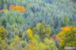
Trossachs National Park
After the majestic, yet desolate splendour of Glen Coe, arriving in Trossachs National Park is like arriving in The Shire after you’ve been “there and back again” to the Lonely Mountains. The winding road through Queen Elisabeth Forest Park with the sun piercing the red and yellow leaves, bathing the scenery in green, yellow and orange colours against a blue sky is some of the most picturesque scenery we found in the Highlands.
Ben A’an
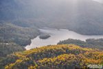
A perfect miniature mountain in the Queen Elizabeth Forest Park, that lies like a Matryoshka doll inside Trossachs National Park. While the hike may only be 3,7 kilometres, the steep climb will take you 454 metres above the sea and provide you with amazing views of Loch Katrine and Loch Achray. The path is excellent yet still demanding, making it an excellent hike for families, giving the kids a real “conquering the mountain” feel, especially with the views at the top.
I almost spurted to the top on wobbly legs, wanting to catch the last rays of the sun before a fair day turned into a dark night. I arrived at the top 1,5 hours before sunset and was awarded with long and golden rays of light, bathing the autumn forest in a warm glow. If you’re in a hurry, it is possible to climb it in ¾ hour, spend 15 minutes on the top and descend in ½ an hour, but I would recommend to take your time.
Good things shouldn’t be rushed and this was by far the most beautiful of our hikes in the Trossachs, partly because of the fair weather.
-

- Arriving in Trossachs National Park is like arriving in The Shire after you’ve been “there and back again” to the Lonely Mountains
-

- Ben A’an is a perfect miniature mountain in the Queen Elizabeth Forest Park
-

- While the hike may only be 3,7 kilometres, the steep climb will take you 454 metres above the sea and provide you with amazing views of Loch Achray
-

- .. and Loch Katrine
-
- Climb it an hour before sunset to be awarded with long and golden rays of light, bathing the autumn forest in a warm glow
-

- This was by far the most beautiful of our hikes in the Trossachs
-

- I made it!!
Conic Hill
As the wind would turn into a storm later that day, we decided to skip Ben Lomond in favour of a smaller hill, but with just as marvellous views of Loch Lomond: Conic Hill. Just like Ben A’an, this sharp little summit gives you a lot of “bang for the buck”.
As you ascent, you’re actually walking on the ridge of the Highland Boundary Fault line, and the string of islands across Loch Lomond lined up with the ridge are all on the fault line. Poetically fitting, that this hike – on the Highland border – would be the last of our hikes in Scotland. This our last hike was ironically the first time we saw a Highland Cow, flabbergasted when I whistled at it, intent on getting that iconic photo.
Due to the increasing wind, we had to cut our hike short, but this 4 kilometre long, 350 vertical metre high trek would make a favourite to families with kids, and judging by the size of the car park it is deservedly a popular excursion.
-
- We decided to skip Ben Lomond in favour of a smaller hill, but with just as marvellous views of Loch Lomond: Conic Hill
-

- As you ascent, you’re actually walking on the ridge of the Highland Boundary Fault line, and the string of islands across Loch Lomond lined up with the ridge are all on the fault line
-
- Poetically fitting, that this hike – on the Highland border – would be the last of our hikes in Scotland
-
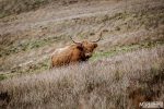
- This our last hike was ironically the first time we saw a Highland Cow, flabbergasted when I whistled at it, intent on getting that iconic photo
-

- Due to the increasing wind, we had to cut our hike short, but this 4 kilometre long, 350 vertical metre high trek would make a favourite to families with kids
-

- Just like Ben A’an, this sharp little summit gives you a lot of “bang for the buck”
More info
The Scottish highlands are are a treat for hikers. The nature is rugged and splendid, yet you can be certain that there’s a cosy pub nearby where you can rest your tired legs in front of a roaring fireplace while contemplating your next adventure.
We used exclusively the routes from Walkhighlands on our trip: They were thorough, with good GPX files, photos, rating and many many options, which made it easy to choose the right hike. Or easiER, since you’re spoilt for choice and know; for every hike you choose, there are 10 others you don’t. That was the reason for us wanting to help you with recommending the best we took, so you don’t waste precious vacation time trotting along boring paths.
See you out there. Be safe!
Learn more


